Author Archive

16 Apr

A Harrowing Drive

In State Highpoints by Robert Danger Byrd / April 16, 2016 / 0 Comments

So I’m at the snowed in trailhead, but much later than expected. The 2WD Toyota Camry was the wrong choice and constantly reminded me so with its racing engine and angrily flashing traction control light as I forced it up the snow covered mountain road.

I suspect that if it snows much more, I won’t be able to get this car back down the mountain and that has me a bit concerned.

But hey, it’s snowing, windy and cold at 21 degrees currently. In fact it’s a terrible day to climb a mountain, just the way I like it.


16 Apr

Driving to the Mountain

In State Highpoints by Robert Danger Byrd / April 16, 2016 / 0 Comments

At 1:00 this morning I rolled out of bed, ate some yogurt, completed my foot taping ritual and headed out the door. Heeding the sage advice; “A good hiker is a lazy hiker”, I took the elevator down conserving five flights of energy.

I then hopped in the rental car, where I am now and left the Twin Arrows Resort which employs 1600 Navaho Indians who generally could care less if I was there or not.

Barring any freak tumbleweed accidents, I’ll be on the mountain within an hour.

15 Apr

Winter Attempt of Humphreys Peak in the Morning

In State Highpoints by Robert Danger Byrd / April 15, 2016 / 0 Comments

Early tomorrow, I’ll be making a winter attempt of Humphreys Peak the Arizona state highpoint. Most folks climb this one in the summer, but I like winter climbing as it is typically more challenging and has air conditioning.

My work schedule has kept me from training as aggressively as I usually do lately, and I’ve been sick for the last week, so I’m not feeling particularly strong. But my pack despite containing snowshoes and all manner of winter equipment is relatively light at just over 30lbs.

I’m expecting a cold and windy climb, with some nice scenery. Hopefully I’ll get some nice photography to share with you.


14 Apr

Heading for Arizona State Highpoint #43

In State Highpoints by Robert Danger Byrd / April 14, 2016 / 0 Comments

Susan and I fly out this morning for a weekend trip to climb Humphreys Peak, the 12,637 ft. highpoint of Arizona. Its a one day climb, but there looks to be some snow and temps near zero high up on the mountain, so it should be a challenging climb.

Well be flying into Phoenix, then we’ll drive up to Flagstaff taking the scenic route through Sedona. I’ll make the climb on Saturday and then Sunday well spend a day exploring the amazing scenery in Sedona which I feel is some of Gods most spectacular Earth-Art before heading back to Phoenix and flying home.

This will be state #43 and I have until October 29th this year, so there are a more quick trips like this planned to whittle them down. As always I’ll be making random posts along the adventure.

23 Jan

Britton Hill, FL Trip Report Posted

In State Highpoints by Robert Danger Byrd / January 23, 2016 / 0 Comments

On  Friday, January 22nd 2016, I stood on Britton Hill, the 345′ state highpoint of Florida watching a soggy but enjoyable sunrise while smoking a Puerto Rican cigar.

This highpoint trip was taken in “BigByrd” our 41′ motor coach and it was #42 out of the 50 states for me.

You will find the entire trip report here.

Highpoint Statistics:
Summit Date: Friday, January 22nd 2016
State: Florida
Elevation: 345′
US Rank by Height: 50th
Round Trip Hiking Distance:NA
Round Trip Hiking Time: NA

Highpoint Links:
Photo Gallery
Posts
Trip Report

To view a sortable table of all of the highpoints with completion dates, trip reports, photo galleries, blog entries an GPS tracks, visit the US State Highpoint Progress Page.

06 Nov

Wheeler Peak Trip Report Posted

In State Highpoints by Robert Danger Byrd / November 6, 2015 / 0 Comments

We had some excitement on the return trip which I blogged about in the Return Trip Challenges post. However the repairs held and we made it back home from New Mexico without further mechanical issues. The climb was a hard won success, and I just barely managed to carve another notch in my ice axe. The Wheeler Peak trip report is posted in its entirety right here.

To view a sortable table of all of the highpoints with completion dates, trip reports, photo galleries, blog entries an GPS tracks, visit the US State Highpoint Progress Page.

Wheeler Peak Trip Report
On Wednesday, October 28th of 2015, after fighting my way up steep slopes through deep snow, I fought to stand in 60+ MPH winds atop the 13,161′ summit of Wheeler Peak the highest mountain in New Mexico.

This highpoint trip was taken in “BigByrd” our 41′ motor coach and it was #40 out of the 50 states for me.

Highpoint Statistics:
Summit Date: Wednesday, October 28th of 2015
State: New Mexico
Elevation: 13,161′
US Rank by Height: 8th
Round Trip Hiking Distance: 8 Miles
Round Trip Hiking Time: 13 Hours

Highpoint Links:
Photo Gallery
Posts
Trip Report
GPS Track


31 Oct

Return Trip Challenges

In State Highpoints,Travel by Robert Danger Byrd / October 31, 2015 / 0 Comments

We only made it as far as Las Vegas, New Mexico today, as we were  presented with some interesting challenges.

Snowstorm!
First, we got caught in a snowstorm driving through the already treacherous mountain roads between Taos and Las Vegas, NM. The conditions were icy and visibility was low, and the tight curves and ups and downs didn’t help. The 32,000 pound coach was sliding a bit, and at one point a Subaru wagon slid over into our lane missing us by inches. We would have liked to pull over and wait it out, but there was no safe place to stop on the narrow mountain roads, so we took it very slowly and made it down the other side where the snow turned to rain.

The mountain roads were icy quite challenging

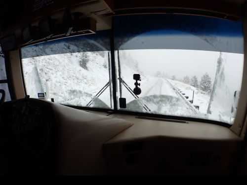
The icy mountain roads were quite challenging

Air Suspension Malfunction 
As we approached Las Vegas, the air suspension began to lose pressure so we pulled into a high school football stadium so I could crawl under the coach and investigate. As I crawled around under the coach freezing rain washed under the coach drenching me from head to toe, but I could not find the problem. We decided to head to a nearby campground to get some rest and deal with the problem tomorrow. We attempted to leave the parking lot, but the suspension had continued to dump and the fiberglass nose hit the ground so I could not move forward without causing serious damage to the coach. And now the coach was so low, I could not back up on account of a monster speed bump behind us. So we were stuck in the entrance to the football stadium with a game starting. Needless to say, we were not very popular.
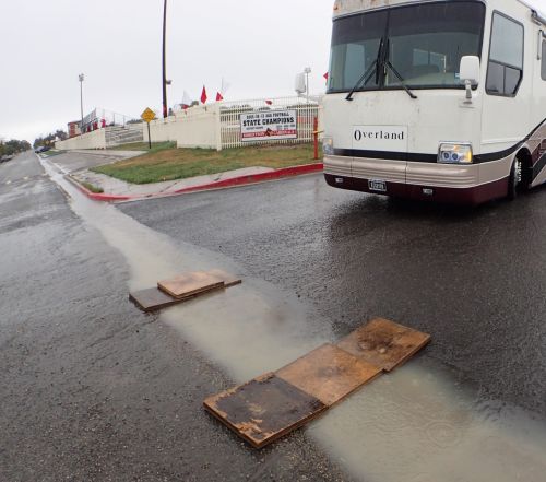
A bridge to freedom

A bridge to freedom

As a hail mary, I decided to try using our jack pads to build a bridge through the low spot, and low and behold it worked!

Clearing the ground by centimeters

Clearing the ground by centimeters

So we were out of the parking lot, but were only able to drive a few hundred feet before we lost all air. In big coach like this the brakes lock up with powerful springs and are released with air pressure just like a semi truck, so without air pressure the brakes lock up. Now we are sitting on the side of the road unable to move, meanwhile the annoyed football fans are honking at us for inconveniencing them.

Air System, Smair System
It is a very complex air system that manages the suspension as well as brakes and has a complete backup system for redundancy. I was not sure how to troubleshoot the system as I’ve never had to monkey with it. I did have the service manual scanned so I changed into some dry clothes and sat down on the sofa to try and figure out what to do next. Feeling like I had a slightly better understanding, I took the Jeep, bought a creeper (much nicer than crawling on wet pavement), and went back under the coach looking for a damaged line, or something obvious, but could find nothing.
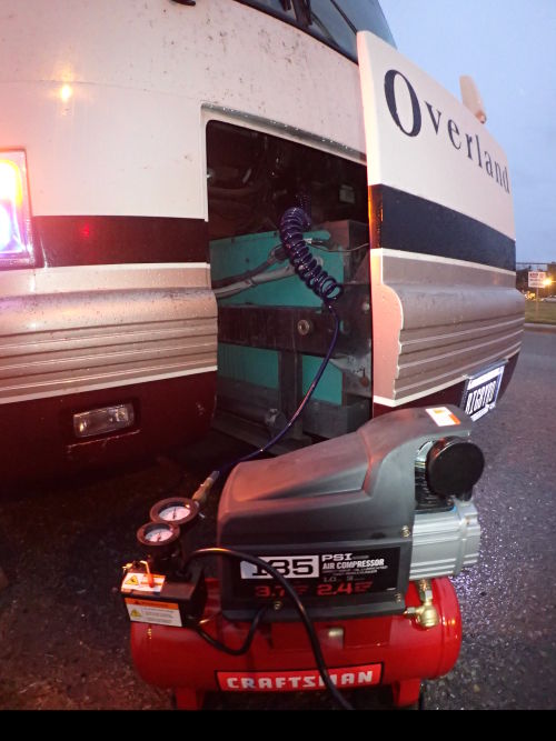
Sears to the rescue

Sears to the rescue

The system was simply not replenishing the air supply as it typically does, so I threw another hail mary. This time, I picked up a Sears Craftsman compressor, spliced it into the system, and fired it up. It took a long time, but eventually the air pressure came back up allowing us to limp to a nearby campground.

Yes Dear, I totally have it under control
I was really feeling out of my depth and not sure what to do,but Susan was not worried at all. She really thought I had everything under control and I didn’t want to tell her otherwise, but I was sweating bullets. Maybe it was luck, maybe it was the prayer, but I was quite relieved to see those air gauges come to life.

My plan is to install the Sears compressor in the basement tomorrow to keep the air system pressure up, and hopefully that will get us back to Texas.

30 Oct

Salty Dog Cantina, by Susan

In State Highpoints by Robert Danger Byrd / October 30, 2015 / 2 Comments

I laughed when Susan shared this story with me, so I encouraged her to write her first Danger blog post.

from Susan’s vantage point
As I strode into the Stray Dog Cantina, the proprietor yelled “Keep it clean, boys; there’s a lady in the house.” The only others in the cantina were nine burly men lined up at the bar, trading salty tails of mountain bravado. I took a table as far in the back as the tiny bar allowed. The proprietor walked up to me saying, “Sorry for the crowd, but it’s all I’ve got.” I ordered their only red and felt so conspicuous, I was compelled to explain that I was meeting my husband soon, as he was descending from the summit of Wheeler Peak. To which he said, “I hope he’s alright, because those three guys getting sloshed at the end of the bar are the mountain rescue team.” This was not particularly reassuring, and overhearing their slurred conversation that went something like this didn’t help:

“A local gets killed up here and nobody gives a @*#!……but let an outsider die and we never here the  @*#!  end of it…….and if a kid bites it, all hell breaks loose…those  @#$@*%#  reporters! They really rake us over the  @#$@*%#  coals.”

Maybe I should have waited in the Jeep, but the freezing weather drove me inside. Hoping Robert was close, I nervously refreshed my “where in the world is danger?” iPad app.

Susan & Robert at the difficult to reach Wheeler Peak Trailhead

Susan & Robert at the difficult to reach Wheeler Peak Trailhead


This was my second trip up the steep winding road to the mountain. In the dark of morning, I drove Robert towards the trail. Finding several roads closed, we jogged back and forth to gain access to the trailhead. Finally, we made it to a steep, snow covered trail just wide enough for the Jeep. I put on my brave face, locked in the 4 wheel drive and forced the Jeep up the icy terrain until the trail narrowed to a horse’s width. I said a prayer, kissed my husband good bye, and promised I’d be on the other side of the mountain by nightfall, awaiting his return.

29 Oct

One Year Left

In Announcements,State Highpoints by Robert Danger Byrd / October 29, 2015 / 6 Comments

49 Years ago today, Brenda Joyce Byrd gave birth to a screaming 10 pound 11 ounce baby boy and named him Robert Lynn Byrd.

Danger sitting on the Hoosier Hill Rock

Danger sitting on the Hoosier Hill Rock

Robert grew up, (mostly) and a lot of other stuff happened that isn’t really important to this story or particularly interesting for that matter.

So in 2010 after Rick Crapshoot Overholt invited him to Climb Borah Peak the highest point in Idaho he was captivated. At age 45 he changed his name to Robert Danger Byrd and committed to walk, climb or crawl to the highest point in every state in America by age 50.

So 49 years and 40 states under his belt, the 50 by 50 goal  is within reach with 1 year and 10 states remaining.

OK, that’s enough third person, it’s starting to get a little weird.

Your Invitation to the 50 by 50 Celebration
I intend to complete the goal by standing on the summit Guadalupe Peak, the highest point in Texas, at sunrise on my 50th birthday. And, I would like you to join me.

Guadalupe Peak is a 8.4 mile round trip non technical hike with a 3,015′ elevation gain; so anyone who is reasonably fit can climb it.

The trailhead is located at Pine Springs Campground. We will bring our motor coach and establish base camp. Some folks would ascend with me and some would stay behind. After the summit, we would descend and celebrate.

So if you would be interested in participating in this celebration, let me know so we can start planning.


28 Oct

Wheeler Plan

In State Highpoints by Robert Danger Byrd / October 28, 2015 / 0 Comments

Had a hearty breakfast of oatmeal and homemade organic muffins Susan made yesterday. She also baked some organic bread and made me some peanut butter and jelly sandwiches this morning.

We are leaving the RV now and since we are close and I’m taking a different route down, Susan is going to drop me at one trail and pick me up at another.

So this is the route plan. The yellow path is the route from the starting point marked by the hiker and it takes me up the more challenging Williams Lake Route route and then after reaching the summit, I’ll continue North up the ridge along the more scenic Bull of the Woods route for just over 8 miles. The blue truck is where Susan will pick me up, provided she can get up those mountain roads.

We will communicate via the satellite beacon, and if she cannot make it, I will continue down to the alternate pickup for an additional 2 miles to the point marked by the red car.

Wheeler Peak Planned Route

As always, you can follow along real time on the map on the Adventure Map. I have marked these routes and waypoints on the Adventure Map as well.

27 Oct

Climbing Wheeler Peak Tomorrow

In State Highpoints by Robert Danger Byrd / October 27, 2015 / 0 Comments

We rolled into Taos New Mexico Sunday, and it is truly a magical place with vast prairies, mountains and incredibly colorful sunsets.

Taos New Mexico is spacious and dramatic

Taos New Mexico is spacious and dramatic

Weather Flip Flop
I’ve been watching the weather as there have been some snow storms on the mountain, and while I dig extreme conditions, it makes photography challenging especially since I plan to carry a flying camera up the mountain.  The weather report predicted a perfect day tomorrow and some weather today. As it turns out, today was the perfect day, and tomorrow is now calling for weather. I’m going for it tomorrow anyway, and if I don’t make it, I’ll try again Thursday or Friday.

Drone
Been getting comfortable with the new Solo photography drone, and it’s going to be a great tool.

Danger flying his 3DR Solo photography drone at the Rio Grande River Gorge Bridge

Danger flying his 3DR Solo photography drone at the Rio Grande River Gorge Bridge


An aerial photo of the Rio Grand Gorge from waaay up

An aerial photo of the awesome Rio Grand Gorge from waaay up

I love being able to suspend a camera in mid-air anywhere I want, it’s quite exhilerating and I intend to put it to good use.

A drone photo from down inside the Rio Grande River Gorge

A drone photo from down inside the Rio Grande River Gorge

Wheeler Plan of Attack
I’ll be on the mountain early and will be posting from the satellite beacon as usual. Some people split this one into 2 days, but I’m going to do it in one. It is going to be a full day as its a big climb with a 4,500′ elevation gain and I’m traveling heavy with the drone and supporting equipment.  My plan is the go up the shorter but steeper, more technical route on the way up, and take the longer more scenic route on the way down.

24 Oct

In Route to Wheeler Peak New Mexico

In State Highpoints by Robert Danger Byrd / October 24, 2015 / 1 Comment

Passed into the Land Of Enchantment half an hour ago and many large and juicy bugs had to die to get us here. Next stop, Albuquerque New Mexico, and yes I had to rely on the spell checker for that one. We will head north from there on our way to Wheeler Peak which at 13,161’ is the state highpoint of New Mexico.

Wheeler Peak Drive

BigByrd
Once again, we are traveling in our remodeled 41’ motor coach we lovingly call “BigByrd”. The new 200 Amp computer controlled alternator is performing flawlessly, however the 4 year old house batteries are weak, so I bridged the house bank with the chassis bank again to steal power. Before the next trip, I plan to convert to one large AGM bank which will eliminate battery maintenance which I despise and boost us from 450 Ah to 900 Ah (able to pull 900 amps DC current for a full hour).

It really pays to have a chauffeur, as I’m able to get quite a bit of work done. It’s not cheap though, this one I have to buy expensive cars, clothes and jewelry.

A 72 Ounce Steak
Last night we stayed in Amarillo Texas, and obviously we dined at the Big Texan Steak Ranch home of the 72 Oz Steak challenge. It costs $72 dollars, but if you can eat it in one hour, it’s free. I was going to take the challenge, but Susan exercised her veto powers. I was in the mood to do something totally out of control, so I bought some fudge instead.

Let's go have some steak!

Let’s go have some steak!

The Big Texan is  a Texas institution and there is a lot of interesting history here. The original Big Texan was opened in 1960, along Route 66 by R. J. “Bob” Lee. The towering sign of a long-legged cowboy that Bob erected next to the building became a distinct landmark on Route 66. The steak challenge began in the early years and became wildly successful as a marketing campaign. Even if you yourself have not been here, you have probably heard of the Big Texan.

In the early 1970s, Interstate Highway 40 replaced Route 66 as the major traffic lane so Bob Lee purchased land along the route for the new highway and built a bigger and better Big Texan Steak Ranch along I-40. The iconic giant cowboy, was moved by helicopter from its original location to the new restaurant where he stands long, tall and proud today.

Cadillac Ranch & Crashing Drones
We originally were going to head straight up to Taos from Amarillo, but are diverting to Albuquerque to get some parts for my photography drone which I crashed while trying to shoot some sunset footage of Cadillac Ranch. It was of course totally Susan’s fault.

Last time I was at Cadillac Ranch sunrise and there was a storm coming

Last I was at Cadillac Ranch in 2014 was during sunrise with a storm approaching

If you have never stopped by Cadillac Ranch, you are missing out on another interesting bit of Texas history. It’s a series of Cadillac’s representing the major line changes  buried nose down. It was conceived by Chip Lord, Hudson Marquez and Doug Michels and funded by Stanley Marsh III an eccentric Texas oil man. The cars are completely stripped now, but most were running when it was originally installed. Today they are covered in a layers of graffiti several inches thick, which grows every year. Interesting side note, the cars are buried at the same angle of the Great Pyramid of Giza in Egypt.

A photo I shot the last time we passed through Amarillo

Another photo I shot the last time we passed through Amarillo during the Oklahoma highpoint trip

Sources:
https://en.wikipedia.org/wiki/Cadillac_Ranch
http://bigtexan.com

08 Oct

Danger Shares Denali Experience at the Seabrook Rotary Club

In Announcements by Robert Danger Byrd / October 8, 2015 / 0 Comments

Around 4 years ago Susan and I met a delightfully friendly woman by the name of  Kay Schroeder while dining at an Asian restaurant with communal tables. Kay started following my adventure blog and recently invited me to speak at the Seabrook Rotary of which she is a member. Having been a former Rotarian myself, I have a high regard for the organization, so I agreed.

A Standing Ovation
So this morning, I shared my Denali Experience using a slide deck of photos, gear info & climbing routes. The Rotarians were very engaged, asked a great deal of thoughtful questions and made me feel welcome.

I was especially touched by the warm and gracious standing ovation 😉

Will Speak for Food
I made some new friends and really enjoyed telling my tale. So if you might be interested in me sharing my Denali experience with your group, just let me know.

Document Links
And for those of you who asked for the slide deck and gear list this morning, here are those links:
Danger’s Denali 2015 Gear List
Danger’s Denali 2015 PowerPoint Deck

06 Oct

Backbone Mountain Trip Report Posted

In State Highpoints by Robert Danger Byrd / October 6, 2015 / 2 Comments

This is the final trip report from the East Central Trip and after 3,224.4 miles and 436 gallons of diesel fuel I’m 6 states closer to the 50 state highpoint goal. This trip included Spruce Knob WV, Backbone Mountain MD, Mount Davis PA, Campbell Hill OH, Hoosier Hill High Point IN, Taum Sauk Mountain MO. Below is a GPS track of the entire trip with each of the completed highpoints plotted on it and there is an interactive zoomable map located here.


The GPS track of the entire 3,200 mile trip with the 6 state highpoints flagged

The GPS track of the entire 3,224 mile trip with the 6 state highpoints flagged

The current count is at 39 states, so there are only 11 remaining now. There are 13 months before my 50th birthday so the 50 by 50 goal is on track and I intend to achieve it. The next state will be California’s Mt Whitney which at 14,494′ is the tallest mountain in the lower 48 and is scheduled for next month (November 2015).

Hanging In St. Louis
The only significant thing I did not blog about was our time in St. Louis. We had a great time there and had some cool experiences. I have posted a St. Louis Photo Gallery here and I may create  a post about it later.

We had a great spot behind the Casino Queen just across the river from the St Louis Arch

We had a great spot behind the Casino Queen just across the river from the St Louis Arch


The Backbone Mountain report is posted in its entirety here.

To view a sortable table of all of the highpoints with completion dates, trip reports, photo galleries, blog entries an GPS tracks, visit the US State Highpoint Progress Page.


05 Oct

Spruce Knob, WV Trip Report Posted

In State Highpoints by Robert Danger Byrd / October 5, 2015 / 0 Comments

The 6 State East Central trip is complete and I’m putting the finishing touches on the last 2 trip reports, which are Spruce Knob, WV and Backbone Mountain, MD. Spruce knob was the first highpoint completed this trip and after this one only the Backbone Mountain Trip report remains which I will get out tomorrow.

The Spruce Knob West Virginia trip report is posted in its entirety here. To view a sortable table of all of the highpoints with completion dates, trip reports, photo galleries, blog entries an GPS tracks, visit the US State Highpoint Progress Page.

03 Oct

Taum Sauk, MO Trip Report Posted

In State Highpoints by Robert Danger Byrd / October 3, 2015 / 0 Comments

The trip odometer is at 2800 Miles, and we are back in Texas headed south on 59 making our way back to Houston. It was a successful trip and we completed 6 more highpoints. Susan is driving and I’m at the desk punching out the last of the trip reports.

Texas Map

Taum Sauk Trip Report
The Taum Sauk Missouri trip report is posted in its entirety here. You can access all of my trip reports on the Highpoint Progress Page.

28 Sep

Missing Pie in St. Louis

In State Highpoints,Travel by Robert Danger Byrd / September 28, 2015 / 0 Comments

So we made it into East St. Louis Illinois last night and found a great spot behind the Casino Queen. St. Louis Missouri is just across the river and we can see the arch from the coach. We only have one more highpoint left this trip which is Missouri, and have some extra time, so well stay here another day or two and experience St. Louis as it is our first time here.

Missing Pie
As excited as I am about exploring St. Louis, I can’t stop thinking about pie. You see, the Amish cherry pie made quite an impression on me, but now it’s gone and I’m having a hard time coping.

Read more →

27 Sep

2,036 Miles & Hoosier Hill Trip Report Posted

In State Highpoints by Robert Danger Byrd / September 27, 2015 / 1 Comment

We have clocked 2,036 miles in BigByrd and crossed from Ohio into Indiana earlier today. After completing the Indiana highpoint around mid-day, we decided to push straight through to East St. Louis Illinois. Having already spent a fair amount of time in Indiana I was keen to do something new. I have never been to St Louis, and since we are ahead of schedule we will spend some time there before we do the Missouri highpoint and head back to Texas.

Illinois

The Hoosier Hill Trip Report is posted below in its entirety.  You will find links to all of my highpoint trip reports & photo galleries on the US State Highpoint Progress page.

Hoosier Hill Trip Report
On Sunday September 27th of 2015, I found myself sitting on a rock and not just any old rock mind you. This particular rock rested at the lofty elevation on 1,257′ making it the highest rock in Indiana. This was highpoint #5 of 6 completed during our  2015 East Central Trip and it was #38 out of the 50 states for me.

Read more →

27 Sep

Hoosier Highpoint Completed

In State Highpoints by Robert Danger Byrd / September 27, 2015 / 0 Comments

It was a harrowing climb to the barely discernible summit of Hoosier High Point, but I’m sitting on the rock that marks the 1,257′ top of Indiana.

There is no discernible geographical prominence here (it’s flat), but, it’s a charming setting nestled in the woods at the edge of a cornfield in rural Indiana.

27 Sep

Leaving Ohio & Trip Report Posted

In State Highpoints by Robert Danger Byrd / September 27, 2015 / 0 Comments

After spending a single night in Ohio, we will be leaving today for Indiana where I’ll complete Hoosier Hill the highpoint of that state. It’s only 80 miles further west, so we’ll drop the coach along the interstate and take the Jeep north to the highpoint before continuing on to who knows were. I like this unscripted style of travel, but it’s stresses Susan out a bit.

Campbell Hill Ohio Trip Report
The Campbell Hill Trip Report is posted below in it’s entirety here.