All posts in State Highpoints

15 Aug

Hawkeye Point Trip Report Posted

In State Highpoints by Robert Danger Byrd / August 15, 2016 / 2 Comments

Today finds us in Duluth, camped by Lake Superior at the Lakehead Boat Basin, and we are taking a lazy day here. Tomorrow I plan to take the jeep and make the 3 hour drive up to Eagle Mountain the highpoint of Minnesota, and expect that climb to take about 5 hours. Susan will stay in Duluth, and as always, I’ll be blogging along the way.

The Hawkeye Trip report is posted below in its entirety. For a richer experience with larger photos see the Hawkeye Point Trip Report Page.

Hawkeye Trip Report
Yesterday morning, Sunday August 14th, 2016 Susan and I stood on Hawkeye Point, the Iowa state highpoint enjoying fresh gourmet coffee with warm blueberry muffins as we watched the sunrise over gently rolling farmland. Iowa makes 46 states, and the first of our Great Lakes 4 state trip.

When is the last time you had blueberry muffins on a highpoint? Well that's too log...

When’s the last time you had blueberry muffins on a highpoint? Well that’s too long…

Highpoint Statistics:

Read more →

13 Aug

Great Lakes Highpoint Trip Day 3

In State Highpoints by Robert Danger Byrd / August 13, 2016 / 2 Comments

We are 1’173 miles, 145 gallons of water, 2 Walmarts, and one audiobook into the trip. Tonight finds us in Iowa, camped in a completely empty RV park, next to Hawkeye Point.

Day 3, in the Great Lakes Trip.

Day 3, in the Great Lakes Trip.

Today had us driving through idealistic rolling farmland, with stolid granaries, presiding over neatly fields of cultivated fields stretching into the horizon. Finding ourselves in such remarkable scenery, is one of the great rewards of this highpointing journey. Being in places, so utterly American that you just want to lift your hands to God in praise for the purple spacious skies.

An Iowa sunset, across a field of ripe corn.

A very American sunset, across a field of ripe corn, taken from the highest point in Iowa.

Today was a very good day, I drove the 8 hours from Topeka where we stayed in our second Walmart of the trip to the Iowa highpoint. The Topeka Walmart was built on the site of a the Chief Drive Inn Theater, and as a nod to that bit of history, they left the Chief Drive In Theater neon sign intact. You can read more about that tidbit of history here.

Read more →

12 Aug

Great Lakes Highpoint Trip Underway!

In State Highpoints by Robert Danger Byrd / August 12, 2016 / 0 Comments

Times are hard for the Byrd family, last night we slept in a Walmart parking lot in Ennis Texas. OK, so its not as dire as it sounds, Walmart is a pretty swell place to stop with your RV on long trips. This morning I even brought Susan coffee in bed, which makes her feel loved, and more inclined to drive 😉

As you read this, Susan and I are in BigByrd making our way across America in pursuit of 4 more state highpoints located in the Great Lakes area. My coffee ploy having worked, Susan is at the wheel, and I’m at the desk.


The plan is to catch Hawkeye Point Iowa on our way north, and then continue to the  Great Lakes to complete Eagle Mountain Minnesota, Mount Arvon Michigan and Timm’s Hill Wisconsin. As always, you will be able to follow along real time here on The Danger Map 

Read more →

28 Jul

Back at Humphrey Trailhead

In State Highpoints by Robert Danger Byrd / July 28, 2016 / 0 Comments

I’m back at the trailhead now, in my rental car with the AC blasting chanting “There’s no place like Camry, There’s no place like Camry, There’s no place like Camry.

I must have found my inner pathfinder because I never lost the trail coming down. But I lost it 4 times on the way up.

I got lucky with the storm and stayed out of its reach as I quickly moved down the mountain.

This climb only took me 7.5 hours, but with the rough boot shredding terrain, wrong turns and heat, it felt like a much longer climb.

I’ll write a full trip report later.

28 Jul

inReach message from Danger Beacon

In State Highpoints by Delorme InReach / July 28, 2016 / 0 Comments

Rain and lightning in adjacent valley moving this way. Both shoe soles have come off and have been taped back on. In the treeline now.

28 Jul

inReach message from Danger Beacon

In State Highpoints by Delorme InReach / July 28, 2016 / 0 Comments

Thunderclouds directly overhead, ominous rolling thunder but no rain or lighting. Will be in the relative safety of the treeline soon.

28 Jul

inReach message from Danger Beacon

In State Highpoints by Delorme InReach / July 28, 2016 / 0 Comments

Made the summit, headed back down, multiple thunderstorms converging on mountain now. Don’t hear the sizzle of static charge building, so I’m safe for now

28 Jul

inReach message from Danger Beacon

In State Highpoints by Delorme InReach / July 28, 2016 / 0 Comments

10 minutes from summit, thunder starting, and I just tore the sole off my hiking boot. I carry duct tape for quick repairs, boot taped moving again.

28 Jul

inReach message from Danger Beacon

In State Highpoints by Delorme InReach / July 28, 2016 / 0 Comments

After steep rocky climb over multiple spirit crushing false summits I see the summit. Incredibly thick gnat swarms here. Storm cloud holding, gonna make it!

28 Jul

inReach message from Danger Beacon

In State Highpoints by Delorme InReach / July 28, 2016 / 0 Comments

Not far from summit now but that storm is getting closer. A climber was struck by lightning and died up her last week, so I’m keeping a close eye on it.

28 Jul

inReach message from Danger Beacon

In State Highpoints by Delorme InReach / July 28, 2016 / 0 Comments

Switchbacks are for pansies, climbed straight up through a rock slide and made the summit ridge. Other climbers are turning back due to storm cloud. Not me!

28 Jul

inReach message from Danger Beacon

In State Highpoints by Delorme InReach / July 28, 2016 / 0 Comments

Emerging from treeline soon. Trail not matching GPS, have lost trail 3 times and had to break trail through rugged steep terrain. Off trail at the moment.

28 Jul

inReach message from Danger Beacon

In State Highpoints by Delorme InReach / July 28, 2016 / 0 Comments

Required the trail, not too bad, only lost 20 minutes or so.

28 Jul

inReach message from Danger Beacon

In State Highpoints by Delorme InReach / July 28, 2016 / 0 Comments

Just realized I took the wrong path a while back, have to double back. Hate it when that happens!

28 Jul

inReach message from Danger Beacon

In State Highpoints by Delorme InReach / July 28, 2016 / 0 Comments

Leaving the trailhead now & satellite tracking is active.

28 Jul

Mt Humphrey Take 2

In State Highpoints by Robert Danger Byrd / July 28, 2016 / 0 Comments

Today I make my second attempt on the 12,633′ Mt Whitney.

I did move the climb day up due to potential thunderstorms tomorrow, but when I checked the weather this morning it looks fine either day. Since I was geared up, I decided to go ahead and get it done today.

The drive up the mountain road was not as exciting as last time in the absence of fresh deep snow.

I’ve got less than 25 pounds of gear all in, and it’s cool in the 50s at the moment, so it should be an easy day. Although I do expect extreme heat later on. It was 115 degrees yesterday during the drive from Phoenix.

I’m at the trailhead now getting geared up and will be leaving soon.

27 Jul

Second Attempt on Humphreys Peak AZ

In State Highpoints by Robert Danger Byrd / July 27, 2016 / 0 Comments

A tall dangerous man steps off a plane, the other passengers give him a wide berth, as he purposefully makes his way up the ramp…

Yea, that would be me. Today I find myself in Arizona in full adventure mode. I’m here to take a second swing at Humphreys Peak, the highest mountain in Arizona and this time, I will not be denied. When I tried this mountain in April, I got caught in a proper blizzard, and had to turn around around 1,400′ from the summit.

Severe weather forced me to abort the first Humphrey attempt in April.

Severe weather forced me to abort the first Humphrey attempt in April.

The chance of blizzards is pretty low this time around, but the heat could be problematic, its 113 degrees in Phoenix today but it will be cooler on the mountain, hopefully a lot cooler. Then there are thunderstorms forecasted this week. My original plan was to take a rest day on Thursday and climb Friday, but the weather looks more favorable on Thursday. So well see what the mountain has to throw at me this time, and hopefully I’ll be up to the challenge.

Highpoint Statistics:
State: Arizona
Elevation: 12,633′
US Rank by Height: 12th
Round Trip Hiking Time: 7 Hours

If you have some time to kill, you can read that first trip report here.

In the meantime, stay tuned to the Danger Network…

24 Jul

Mt Hood Trip Report Posted

In State Highpoints by Robert Danger Byrd / July 24, 2016 / 0 Comments

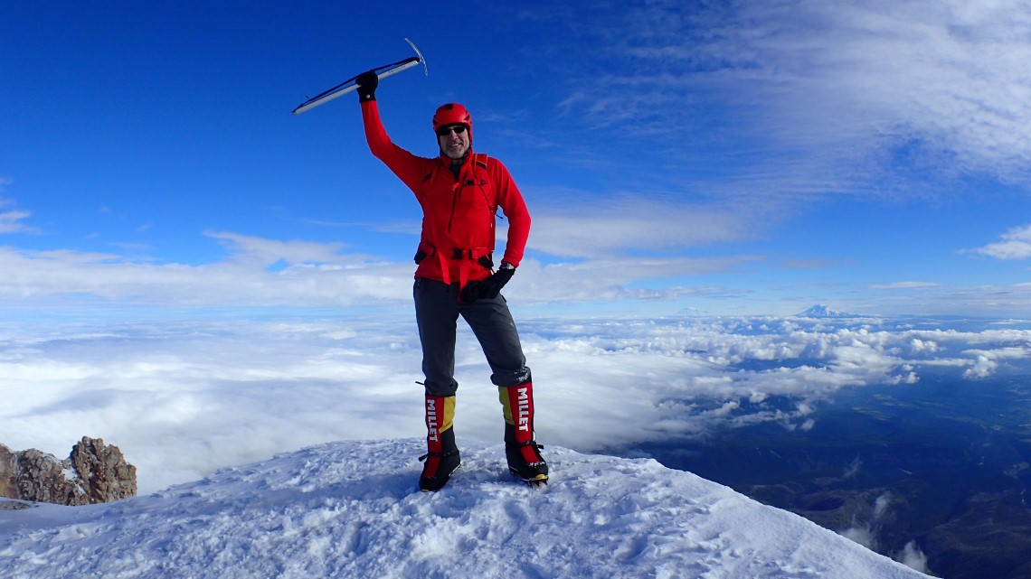
Tuesday July 12th, 2016 I stood on the summit of Mount Hood, the state highpoint of Oregon. This was #44 out of 50 for me. This was a hard won summit, with my first attempt ending in failure after being turned back 700′ from the summit due to weather. The second attempt was also not without its challenges, so when I finally did make it, it felt like I had really accomplished something.

Hood has a reputation for nastiness, and has killed over 130 people. It’s one of the higher death tolls for US mountains. Even so, I was still surprised the intensity and variety of her wrath. Why is Hood a female? Because a male mountain doesn’t really care if you climb him or not, he’s indifferent. But a female mountain will fight you all the way to the top. And fight she did, throwing freezing rainstorms, icy winds, whiteouts, avalanches, hailstorms and even a fall for good measure.

As I mentioned, it took two attempts to bag this one, and the stories are tightly linked, so I have combined them both into this one trip report.

A very happy Danger stands on the summit of Mount Hood.

A  happy Danger stands jauntily on the summit of Mount Hood.

Highpoint Statistics:
Summit Date: Tuesday July 12th, 2016
State: Oregon
Summit Elevation: 11,249′
Trailhead Elevation: 5,860′
Elevation Gain: 5,389′
US Rank by Height: 13th
Round Trip Hiking Time: 13 Hours

Highpoint Links:
Trip Report – You will see larger photos here.
Posts
Photo Gallery #1
Photo Gallery #2
GPS Track #1
GPS Track #2

To view a sortable table of all of the highpoints with completion dates, trip reports, photo galleries, blog entries an GPS tracks, visit the US State Highpoint Progress Page.

About the Mountain
Mount Hood, was called “Wy’East” by the American Indians who once inhabited the area. Hood is a potentially active stratovolcano located only 50 miles east of Portland. Steam is constantly spewing from fumarole areas and sulfuric gases are a hazard for climbers. Eleven glaciers grace Mt. Hood’s peak and the Timberline Ski Lodge is situated at the base of the mountain. At 11,249 feet, it is Oregon’s highest mountain as well as being one of the most visually impressive mountains in the nation based on its geographical prominence.

Read more →

12 Jul

Mt Hood Oregon HP #44 Complete

In State Highpoints by Robert Danger Byrd / July 12, 2016 / 3 Comments

So state highpoint #44 is officially in the bag. I’ve been back at the trailhead for an hour, loading & sorting gear, changing out of my wet clothes, which was not fun in freezing windy conditions.

This was a very big day. A full 13 hours of non stop intensely physically challenging and technically demanding work. This was the most technical mountain I have climbed yet, and it definitely sharpened my skills and showed me some weak points.

I’ll post a report later, but for now, I’m going to go find me a wilderbeast to eat.

12 Jul

inReach message from Danger Beacon

In State Highpoints by Delorme InReach / July 12, 2016 / 0 Comments

And now its raining and extremely windy.