08
Jul
inReach message from Danger Beacon
Quickly made our way down through the accursed rain, & are back at camp. We both got very wet, but my technical layers are keeping it off my skin so I’m warm

Quickly made our way down through the accursed rain, & are back at camp. We both got very wet, but my technical layers are keeping it off my skin so I’m warm
Turning back only 700 vertical feet from summit, conditions rapidly deteriorating, and visibility is very limited & worsening.
We are beyond the freeze line and into the low pressure zone, but visibility is limited. We are going to wait a bit, but Ben is considering turning back.
3:26AM Light rain now, so we are gearing up and moving out soon!
2:30AM and rain is back, so we wait for an opportunity. It is well below freezing higher up, so we need to stay dry or we risk hypothermia.
I do love a good challenge but don’t care to become a DangerSickle.
Had a hearty breakfast, and will continue consumption of mass quantities until we leave. Summit day on hood is 8-12 hours and a man my size will burn around 7,000 calories on such a climb.
Our low pressure window up high has expanded, so weather up higher should be better for longer, we just need to get above the rain/freeze line.
For now, we wait…
12:30 AM Update:
Temp hovered just above freezing and it rained most of the night.
High humidity and cold irritating my throat and sinuses.
There is a low pressure window at 5:00 AM that may give us an opportunity to summit. We need to be in position at the Hogs Back Ridge below the summit to take advantage of it.
Windy but no rain, so we will be moving higher on schedule.
Been sleeping since 4:00 PM, and will wake at 12:30 gear up and move out weather permitting. Rare to get a good nights rest before summit day. Have literally had as little as 3 hours before a 16 hour summit day so getting a full night is quite a luxury. Sunset was at 9:00 and it’s a bit challenging to sleep with the light. Wind buffeting the tent also does not help, but eventually it becomes normal and I awake when the wind stops.
A medium sized rock from high on the mountain just rolled into our tent, which is a bit unsettling. Hopefully we don’t get any large boulder visitations.
Ominous clouds line the horizon, & forecast looks bad for summit attempt tomorrow. We are going to push for it, but chances of success are 50% according to my very personable guide Ben.
Ben suggested we take the ski lift partway up which shaved 2.5 hours off the climb. I told him I felt like a dirty lowdown cheater but he wanted to beat the rain and it was a good call as it started raining soon after camp was complete. I’ve been caught in rain before and all of my clothing layers, sleeping bag, socks, everything got wet and did not dry for days. Trust me alpine climbing in soggy underwear is not fun.
We will wake at 1:00AM, if storming we will try later.
Ben is a Sagittarius.
Spent 1.5 hours digging out level tent site on mountainside at 8769′. Beat rain by minutes. 50 deg, light wind & raining, heavy driving rain expected later.
Geared up & ready, 60lbs w shared equip. Weather turned nasty already, high wind, cold & snowing. Extreme, just the way I like it!

Tomorrow, I’ll be climbing an active volcano covered in glaciers and loose avalanche prone snow. It’s not really as crazy as it sounds, well maybe it is…
The aforementioned mountain is Mt Hood, the tallest mountain in the state of Oregon and my 44th state highpoint if all goes according to plan. Hood is only 11,249 feet tall, but it has a nasty reputation and a respectable 5,319′ elevation gain exceeded only by Denali and Rainier. Over 130 climbers have died on Mt Hood, typically due to falls from the steep icy slopes, but avalanches which are more common on steeper mountains, have claimed their share of lives as well. In addition to steep and technical slopes, there are also active steam vents and sulfurous discharges that destabilize the snow thanks to the volcano under the layers of glaciated ice. It will most likely be snowing, and due to the constant snow, there aren’t any trails. And oh yea, it will be windy and well below freezing, sounds perfect!
I wont be going alone, as I opted for an experienced private guide with no other climbers to eliminate the chance of a weak climber creating problems and potentially turning us around which is common on tough mountains. Hopefully I wont be that weak climber. We will start up the Mountain on Thursday July 7th, camp overnight and make a summit bid on the 8th. If I do not make it, I will cancel my return flight and make another attempt as mid July is the end of the climbing window on Hood as the sun heats up the slopes in the summer months, the snow begins to give way causing frequent avalanches. And I need to finish by October 29th this year to meet my 50 by 50 goal.
I’ll literally be watching my step on Hood. This type of climbing requires hyper focus as every footstep must be perfectly placed, since a blowout can be deadly. It is definitely not a casual climb, but I’ve done this type of extreme mountaineering before, and I have been training hard and feel ready. I’m stoked and really looking forward to seeing if I’m up to the challenge that Mt Hood presents.

On Friday June 3rd I stood at the highest point in Illinois with my good friend and highpointing mentor Rick Overholt. This was my 43rd highpoint and Ricks 48th.
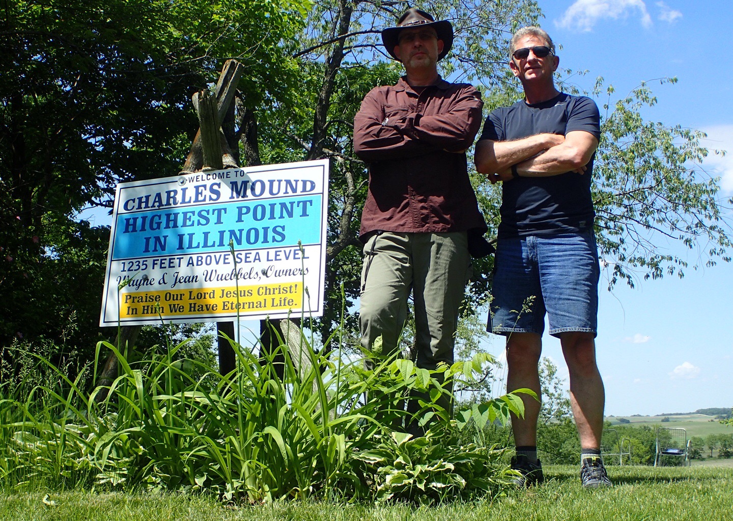
A pair of very manly men standing at the highest point in Illinois
Highpoint Statistics:
Summit Date: Friday June 3rd, 2016
State: Illinois
Elevation: 1,235′
US Rank by Height: 45th
Round Trip Hiking Time: 20 Minutes
Highpoint Links:
Posts
Photo Gallery
Trip Report
GPS Track
You will find the entire Trip Report posted here. To view a sortable table of all of the highpoints with completion dates, trip reports, photo galleries, blog entries an GPS tracks, visit the US State Highpoint Progress Page.
Rick and I are now standing on the highest point in Illinois.
The land owners are using it as a witnessing opportunity with a sign proclaiming,”Praise Our Lord Jesus Christ! In Him We Have Eternal Life.”
We checked the guest register and we are the first to come within the authorized window this season.
It is very relaxing here; quiet with clear skies, gentle winds and long views over rolling farmland. It’s a perfect day to stand on a highpoint!

We are 30 minutes into the 3 hour drive from downtown Chicago to Charles Mound and are already close to exhausting our repertoire of driving games. Rick plays a mean game of iSpy and I’m about $700 down already, but I’m hoping to make it up in a game of high stakes License Plate Bingo.
The Highpoint
Charles mound is an easy 2.5 mile round trip hike. The challenge here is logistical in nature, as this highpoint is located on a private farm and therefore public access is limited to 4 weekends a year; the first weekend of June, July, August, and September.
Fun Fact
The Sears Tower (Now the Willis Tower) in Chicago rises 1,450 feet above ground with a ground elevation of 583 feet. That puts the top of the Sears Tower at an elevation of 2,033 feet above sea level, nearly 800 feet higher than Charles Mound. However, it is obviously not considered to be the state highpoint since it is man made.

This morning I woke up on a sailboat along with my good friend Rick Overholt. No is isn’t one of those stories where there’s a tiger locked in the bathroom and people are missing. This is a story about a journey to stand on the high places of America, and it’s a story that is drawing to an end in a matter of months. But I digress, so let’s get back to the boat.
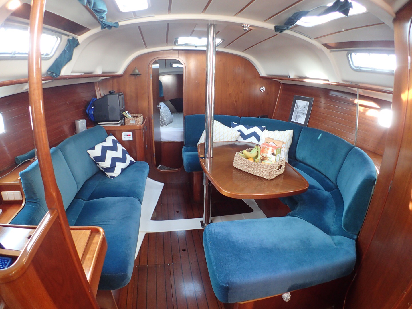
The Beneteau sailboat has a nicely appointed cabin.
This particular sailboat is docked in Belmont Harbor in the shadow of downtown Chicago, and it belongs to freind and fellow mountain climber JR Peacock. It’s a classic 35′ Beneteau with Twin cabins, rich woods, and a full suite of amenities. JR Spends a month or two out of every year traveling on it and it is going to make a great home base from which to tackle the Indiana highpoint, and experience a bit of the Chicago culture.
The Highpoint Plan
Tomorrow, Rick and I we will make our attempt on Charles Mound the 1,235′ state highpoint of Indiana and this will be number 48 for him and 43 for me. I say “attempt” because after getting shut down on the Arizona highpoint in April I’m not taking anything for granted. That said, this is an easy one, and the only challenge is that it is only accessible 3 weekends out of the year. It’s on private property, and the owners limit access. So barring blizzards, floods, tornados or frog plagues, we should have this one completed tomorrow.

So we are back in Houston and I didn’t make it to the summit of Humphrey Peak the first try. I will go back later and make another attempt, but in the meantime here is the full Trip Report of that failed attempt.
Highpoint Statistics:
Summit Attempt Date: Saturday, April 16th, 2016
State: Arizona
Elevation: 12,633′
US Rank by Height: 12th
Round Trip Hiking Time: 6 Hours
Highpoint Links:
Posts
Trip Report
To view a sortable table of all of the highpoints with completion dates, trip reports, photo galleries, blog entries an GPS tracks, visit the US State Highpoint Progress Page.
Made it back to the trailhead with weather chasing me all the way down. Now the whole mountain is socked in. Now to wrestle this Camry back down the mountain
Below the worst of it now & looking back in glad I turned around. Much more of the mountaintop is socked in now. I’d be blind now if I stayed where I was
Getting worse, whiteout coming down mountain. I have to descend and hope it doesn’t overtake me. Wind is insane!